Showing posts with label continents. Show all posts

FREE European Countries Fact Cards and {Learn & Play Link UP}

Wednesday, 25 November 2015

There are amazing shared printables this week! Before I go there, let me share with you my FREE European Countries Fact Cards that we used in our European Study Unit and The Study of Northern Europe. Mavi loved these cards, he keeps on reading them and learning about the currency, highest mountain, longest river etc. of 16 European countries.  Download your copy now!

Europe Countries


xxxxx (1 of 1)-51

 
Welcome to the Learn & Play Link Party!
Here are the featured literature-based activities for this week!
 
LinkUP
 
Do You Want to Make a Turkey from Sight and Sound Reading
Letter D Printable Pack from Welcome to Mommyhood
 
11206071_10206383760770609_4191824351964193280_n
Now it’s time for this week’s link party! This is a BRAND new link up for all blog posts that include learn and play activities and hands-on education for kids. We are excited to read your blog posts and to see what you have to share! Please link up below and grab our button to display on your blog.
If you are a blogger, share your family friendly posts here. We are looking for things which include:
  • Montessori Education
  • Homeschool
  • Sensory Play
  • Tot and Preschool Trays
  • Fine and Gross Motor Activities
  • Kids in the Kitchen
  • Healthy Recipes for Kids
  • Arts and Crafts
  • Natural Living
  • Free Educational Printables
  • Family-Oriented Activities
  • Healthy Living
Your post will be featured on each of our blogs where we will pick our favourite posts every other week. That means there is more of a chance that you will be featured!
Everyone, please meet our link party hosts:
learn and play party hostesses
Christian Montessori Blog ~ Please visit our CMN FB group ~ Pinterest

GUIDELINES FOR LINKING

  • Please link up 1-3 posts
  • Follow each of the hosts on social media
  • When you link up, please add our button and place it at the bottom of your shared posts or link back with text link.
  • By entering a link, you’re giving us permission to feature an image on our blogs. Proper credit & links will ALWAYS be given.
  • Please visit a couple of shared posts and leave a comment for them
  • Remember that you must link back in order to be featured
Grab This Button:
Christian Montessori Network
<div align="center"><a href="http://christianmontessorinetwork.com/category/learn-and-play" title="Christian Montessori Network"><img src="http://www.christianmontessorinetwork.com/wp-content/uploads/2015/04/learn-and-play-link-up-150-150.png" alt="Christian Montessori Network" style="border:none;" /></a></div>

Please Follow
Follow Pinay Homeschooler's board Pinay Homeschooler on Pinterest.

The Study of Northern Europe

Saturday, 21 November 2015

*Contain affiliate links*

Mavi and I are looking into the different regions of Europe and we started with Northern Europe (of course, that’s our location!).  So as not to be overwhelmed, we only focused on 4 countries:  Denmark, United Kingdom, Ireland and Sweden (my bestfriend currently lives there and has been sending me lots of beautiful photos!).Northern

So to learn about Northern Europe we have the following activities:

Naming of at least 4 Countries

We start off by identifying the countries in the Northern Europe. If you check my previous post, Mavi sorted out the countries in Europe according to regions.  So in this study we are focusing on four countries:  Denmark (for LEGO), Sweden (for IKEA), United Kingdom and Ireland.

xxxxx (1 of 1)-52

I prepared this  country FACT CARDS for Mavi to read.  Things that you can learn from this fact cards:

  • Capital and biggest city for each country
  • Currency used
  • Language
  • Nationality
  • Longest River of the country
  • Highest Mountain of the country
  • Climate
  • Government

xxxxx (1 of 1)-51

Mapping

I created this Europe Map 3 Part cards.  My intention here is for Mavi to easily identify the location of each country without using the puzzle.  The file also contains a blank sheet for him to do his own mapping.

xxxxx (1 of 1)-50

DSC_0515

Flag and Plotting Important Geographical Sites

For retention, I made Mavi create the flags of Denmark and Ireland using LEGOs.  He wanted it this way, rather than painting or drawing them on a cardstock.

xxxxx (1 of 1)-49

I printed this map of Ireland from CIA site and laminated it.  The purpose of this activity is to locate the highest mountain of Ireland, the capital city and trace the longest river.  We did this with United Kingdom, Denmark and Sweden as well.  In order to reuse the map again, I laminated it and used dry erase pen to mark the map.

xxxxx (1 of 1)-47

Famous Landmarks

For the landmarks, I printed this coloring sheet from Education.com.  Mavi wants to color them but later on decided to create a replica using his LEGO.

xxxxx (1 of 1)-43

DSC_0509

This is his interpretation of the Stonehenge and Big Ben tower using LEGOs.DSC_0580

DSC_0587

Important Facts About Northern Europe

Expanding our knowledge, we took out some of the fact cards from our Europe in a Nutshell, identify those that belongs to Northern Europe and study them.  So here are the things Mavi learned:

  • Puffins. We saw a few of them in Cliffs of Moher when we visited the site last summer.
  • Vikings
  • Shamrocks and Celtic cross in Ireland
  • Fjords in Scandinavian countries.

 xxxxx (1 of 1)-53

Follow us on Facebook, Pinterest, Google Plus, Instagram or Twitter for updates!

And you might as well PIN this post for future reference.

NorthernEurope

Europe Unit Study (Elementary)

Saturday, 14 November 2015

We are revisiting our Europe study, this time I’ve decided to take it by regions.  But before we delve into that, we reviewed some of the things we’ve learned in the past years.

European Regions.  Here’s a new study for this year, learning Europe through each regions.  Here I was showing Mavi the divisions and the boundaries in the map.  I bought this map years ago at Montessori Print Shop.  So we’re doing a color code here based on our map in Europe in a Nutshell.  Blue for northern Europe, red for western Europe, green for eastern Europe and orange for southern Europe.

DSC_0266

Flags. The same goes to the flags. To be able to remember the countries easily, we just limit to 3-4 countries per region. You can get these mini-flags from my Flags of Europe printable.

DSC_0460

We always worked the pin flags because Mavi enjoys this activity.  The pin flags are included in my Flags of Europe file.  My pin flags are really old and has been used so many times.  I shall make a new set for Xavi when he needs it.

DSC_0285

Animals of Europe.  Mavi is sometimes confused of the animal list between North America and Europe so we always review this.  The fact cards seen here are from my Animals of Europe printable (includes 3-part cards as well).

DSC_0386

New activity this year is examining and matching European animals with their covers.  This was a hit!  My animal figures matches the printable. How cool is that?  The animal covers are part of my Europe in a Nutshell and the animal figures are from Schleich.

DSC_0423

Here’s a closer look.

xxxxx (1 of 1)-21

Landmarks.  Beautiful and historical landmarks in Europe are too many to mention, so in this study we’re only picking a few based on the regions.  My aunt who visited us early this year brought me a few Safari Toobs and one of which is the landmark toob that includes the Stonehenge in UK and the Colosseo in Rome. You can get the World Landmarks and Around the World Toob from Amazon and the cards are from Europe Landmarks file.

xxxxx (1 of 1)-22

Now to put into action, Mavi worked sorting maps and flags according to regions using our Europe Puzzle Map. More about it here.

DSC_0553


For our past Europe studies and materials, click the links below:

Europe Study Part I

Europe Study Part II

Continent Study: Europe Part I (Kindergarten)

Continent Study:  Europe Part II (Kindergarten)

Materials for Europe Study

Europe in a Nutshell

Learning About the European Regions

Follow us on Facebook, Pinterest, Google Plus, Instagram or Twitter for updates!

And you might as well PIN this post for future reference.

EuropeRevisitPIN

Hands-on Learning on European Regions

Thursday, 5 November 2015

Mavi is into geography once again and we are revisiting Europe.  My approach for this year’s study is to look at Europe through the different regions.  It’s easier to understand and internalize facts when they’re into smaller groups than attacking it as a whole.

So I created these label cards for northern (blue), western (red), southern (orange) and eastern (green) Europe.  The color coding is based on our map in Europe in a Nutshell.  The mini flags seen in the photo is from Flags of Europe printable.

RegionsEuropeFB

He easily identified Greece, Italy and Spain as southern Europe.

DSC_0553

Our Montessori Europe Puzzle Map is from Absorbent Minds UK.


DSC_0556

After he sorted some of the countries, he proceed on completing  the puzzle map on his own.  I provided a control map from Montessori Print Shop.

DSC_0592

I love that he removed the puzzle pieces and placed them on a basket instead of scattering them in the rug.

DSC_0581

More updates on the Europe Continent in the next coming days so stay tuned!

Follow us on Facebook, Pinterest, Google Plus, Instagram or Twitter for updates!

And you might as well PIN this post for future reference

RegionofEuropePIN

Continent Fact Cards Game and {Learn & Play Link Up}

Wednesday, 21 October 2015

DSC_0750

Mavi can’t get enough of these facts cards from my Nutshell series! He wants us to play this when in the car, or just by walking home.  I would ask him a questions based on the facts and he’s going to tell me the continent or the country it’s connected to.  We developed a scheme of giving him 3 clues (mostly letters from the answers) and I am PROBIHIBITED to give the answer. It’s amazing how both Mavi and I enjoyed it.  So happy that we found a new way to use these cards!

These cards are from:

Asia in a Nutshell

Europe in a Nutshell

Africa in a Nutshell

South America in a Nutshell

Welcome to the Learn & Play Link Party!
Here are the featured activities for this week!
 
LinkUp
 
Halloween PreK Fun Pack from The Multitasking Mom
 
11206071_10206383760770609_4191824351964193280_n
Now it’s time for this week’s link party! This is a BRAND new link up for all blog posts that include learn and play activities and hands-on education for kids. We are excited to read your blog posts and to see what you have to share! Please link up below and grab our button to display on your blog.
If you are a blogger, share your family friendly posts here. We are looking for things which include:
  • Montessori Education
  • Homeschool
  • Sensory Play
  • Tot and Preschool Trays
  • Fine and Gross Motor Activities
  • Kids in the Kitchen
  • Healthy Recipes for Kids
  • Arts and Crafts
  • Natural Living
  • Free Educational Printables
  • Family-Oriented Activities
  • Healthy Living
Your post will be featured on each of our blogs where we will pick our favourite posts every other week. That means there is more of a chance that you will be featured!
Everyone, please meet our link party hosts:
learn and play party hostesses
Christian Montessori Blog ~ Please visit our CMN FB group ~ Pinterest

GUIDELINES FOR LINKING

  • Please link up 1-3 posts
  • Follow each of the hosts on social media
  • When you link up, please add our button and place it at the bottom of your shared posts or link back with text link.
  • By entering a link, you’re giving us permission to feature an image on our blogs. Proper credit & links will ALWAYS be given.
  • Please visit a couple of shared posts and leave a comment for them
  • Remember that you must link back in order to be featured
Grab This Button:
Christian Montessori Network
<div align="center"><a href="http://christianmontessorinetwork.com/category/learn-and-play" title="Christian Montessori Network"><img src="http://www.christianmontessorinetwork.com/wp-content/uploads/2015/04/learn-and-play-link-up-150-150.png" alt="Christian Montessori Network" style="border:none;" /></a></div>

Please Follow
Follow Pinay Homeschooler's board Pinay Homeschooler on Pinterest.

EUROPE in a Nutshell

Monday, 12 October 2015

My son’s favourite continent (according to him!) is finally up in my Sellfy store today! I am so excited and happy to announce that I’ve completed our learning material for Europe which is now cooking in the printer, to be laminated and will be used in a couple of weeks for our Europe study!  Mavi just loves my Nutshell series and can’t wait to try it with Vito in the near future!

Europe In A Nutshell

Buy now

Here are the learning materials included  in the file:

1.  Maps.   You will see the different countries comprising Europe and the regions. Familiarizing the regions of Europe will help you understand the people, the diversity in culture and practices.  And, of course… this will be of great help if you want to travel to Europe!

post1

2.  History Timeline Cards.  Europe has significant contribution to world history and I included some of the major events that occurred in the ancient times.    Some of these pictures are taken during our travels!

post2

3.  Fact Cards.  54 cards about Europe! From Count Dracula to Mozart, to the beautiful cities of Rome and ruins of Greece! So many things to learn and explore about this small yet fascinating continent!

post4

4.  Animal Skin Patterns.  My son loves these cards and I just have to include it!  Learn about the animals that lives in Europe and see up-close their unique covers.

post3

5.  Red Fox and Snowy Owl Nomenclature Cards.  These cards are intended for younger learners.  A fun way to learn about a specific animal that thrives in Europe and their different parts.

post5

post6

How exciting!  Can’t wait to share a post on how we use these.  Thank you and hope you like it!

Other Nutshell series available: (Click on the image for the link)

                        asia cover copy    south america cover copysm

                                                                            africa nutshell presentation

Continent Study of South America

Sunday, 30 August 2015

*** Contain affiliate links

SouthAmerica

Map and Flags. Whenever we worked a geography lesson at home(for elementary only!), I always start with maps and flags because I wanted him to memorize the location and flags of certain cities from that continent.  We travel a lot, crossing countries and continents almost every year and so knowing all these is really important.  The Montessori Continent Puzzle is from Tower High Learning.

DSC_0376

DSC_0122

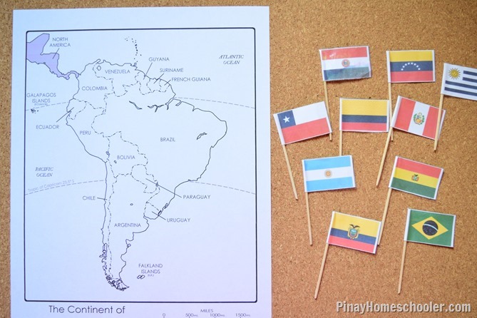
Pinning flags in the map is an activity Mavi loves since we started geography year ago.   I printed the map from Super Teacher and used our pin maps from South American Flags (pin maps, 3 part cards, mini flags and all).
DSC_0709

Landmarks.  We identified the famous landmarks of South America and their location on the map.  I also showed Mavi some photos of my Dad (Mavi’s grandfather) in Brazil when he visited Christ  the Redeemer.  Mavi was fascinated that his grandfather reached South America during his travels!

DSC_0801

Galapagos Islands and its animals.  Using the Safari Toobs Galapagos, we talked about the unique animals that inhabit the islands.  I created identification cards (as reading materials for Mavi) so he will learn what makes those animals unique.DSC_0137


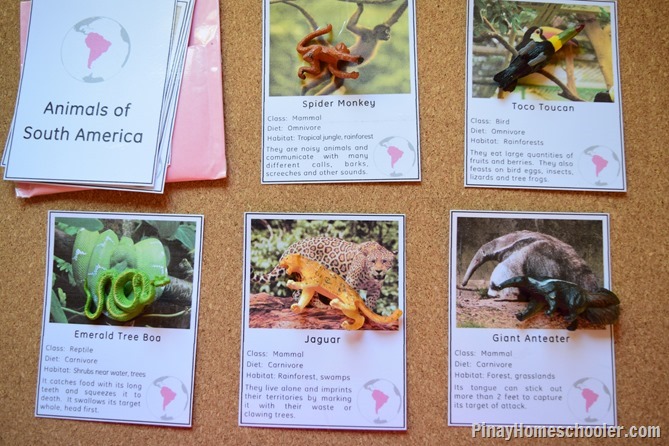
Animals and their Habitats. I love talking about animals and their habitats. My Mavi has always been fascinated with at different animals living in each continent. To start off, we review the different animals living in South America, these cards are from my South American Animals.  There’s so much information from these cards, like it indicates the class of the animal (mammal, reptile, bird etc), the habitat in which they thrive and the kind of foods they eat.  We also matched them with our animal figures from Safari Toob Rainforest.
DSC_0770

We also talked about the colourful animal coverings and patterns of the South American animals and compared them to those in Africa.  Just by looking at the animals’ coverings, you will know in which habitat they thrive.  Most colourful animals like that of Macaw birds and poisonous frogs lives in rainforests, while those that are grayish, thrives in deserts.

DSC_0760

DSC_0742

Because we looked into the animals of South America, we examined the green iguana which mostly lives in that continent.  We haven’t worked on reptiles before, so this was a good start of learning the different parts of a reptile and differentiate it from birds,  fish, frogs and mammals.

DSC_0113

Plants.  Talking about habitats led us to discuss plants of South America.  These plants mostly grow in the tropical areas of the continent and the cold mountains of Andes.  These cards are from the Plant Atlas.DSC_0808


Culture.  I’ve collected important fact about South America and included it in our learning  cards for our South America in a Nutshell.  These cards are for older children who love to read and learn about the culture, lifestyle and religion of the people of South America. DSC_0714
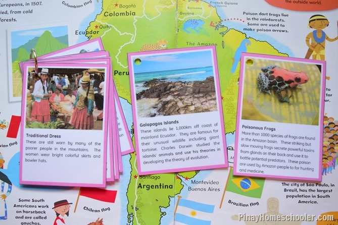
The cards provide information how people dress up, what foods they eat, the products they export to other countries and the richness of each South American countries. 

DSC_0737

Because South America has brought us dances like Tango and Samba, Mavi and I watched a few videos online to see how these dances are being performed.


We also watched the festivals celebrated in South America, like the Tango Festival and the Carnaval in Brazil.

Other materials that we used are the following:

Natural Resources of the World – information about the different natural resources found in each continent.

Animal Habitats – contains collection of animals that thrive in the different biomes of the world. 

Major Rivers of the World – pictures and facts cards of the longest and most important rivers of each continent.

Another fantastic geography lesson we had early this year was the study of Africa. Click here or the image below for ideas and list of activitiesafrica copy

And don’t forget to pin this for later! You will definitely be needing this!

SouthAmerica PIN

Learning materials used:

  • South America in a Nutshell.  More about it here.
  • Animals of South America
  • Landmarks of South America
  • Flags of South America
  • Plant Atlas
  • Animal Habitats
  • Major Rivers Around the World
  • Safari Toobs Rainforest
  • Continent Map from Tower High Learning or from Amazon
  • Safari Toobs Galapagos